


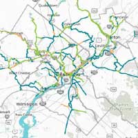
Montgomery County offers its residents and visitors a premier trail system. The Montgomery County Division of Parks, Trails, and Historic Sites is responsible for constructing and maintaining all county trails. We currently have almost 60 miles of regional county trails connecting greenways, waterways, and heritage corridors within Montgomery County and are planning to construct additional trail miles.
Our trails offer panoramic views, wildlife observation, waterways, natural areas, and insight to the history or Lehigh County. Those looking for a challenge can hike or mountain bike the challenging 8.5 mile Border Trail at Trexler Nature Preserve. Those interested less strenuous trails will enjoy the ADA trail at Trexler or Lehigh County's 11 miles of the D&L trail along the Lehigh River from Cementon to the Lehigh Gap Nature Center. Our trails connect to other trails including the 2200 mile Appalachian Trail, other sections of the 165 mile D&L Trail, the Jordan Creek Greenway, the Slate Heritage Trail, the Ironton Rail Trail and the 14 miles of trails at the Lehigh Gap Nature Center.
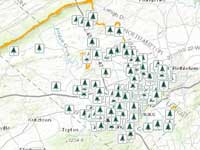
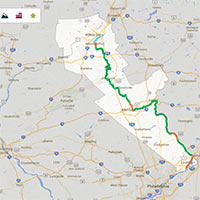
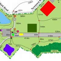
The Route 202 Parkway trail is an almost nine-mile long, 12-foot-wide paved trail along the new parkway running from Doylestown to Montgomeryville. There are 5 trailheads with parking at Knapp Road, Route 309, Stump Road near the County Line Road intersection, Bristol Road, and New Britain Road. Trail Map >


© BucksCountyAlive.com - Mikula Web Solutions. All rights reserved.
Redistribution of coupons in printed or electronic form is prohibited.


